The Wines of the California Central Coast
Growing Regions
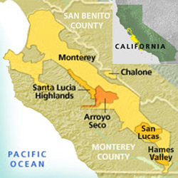
Monterey and San Benito Counties
Monterey County has 80 miles of Pacific coastline and has a wealth of diverse mesoclimates within this stretch. San Benito County lies to the east of Monterey County for most of the latter’s length.
The primary AVA in this region is the Monterey AVA which includes the areas around the town of Monterey and the southern half of Monterey Bay east to the Salinas River Valley. This area is cooler with regular cloud cover and morning fogs and does well with Chardonnay. There is little rain.
Several smaller AVAs exist within these two counties:
- Arroyo Seco AVA
- Chalone AVA
- Santa Lucia Highlands AVA
- San Lucas AVA
- Hames Valley AVA
In Benito County, there are also several small, little-used appellations: San Benito, Paicines, Mount Harlan, Cienega Valley, Lime Kiln Valley and Pacheco Pass (which partly resides in Santa Clara County).
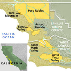
San Luis Obispo and Santa Barbara Counties
Just south of Monterey County is San Luis Obispo County, and south of that lies Santa Barbara, which marks the end of the Central Coast. Santa Barbara has a cool climate due to the influence of the Pacific Ocean and a string of east-west valleys that allow sea breezes to penetrate far inland.
The largest AVA within the two counties is Paso Robles which covers the inland portion of the northern half of San Luis Obispo County. This is the headland of the north-flowing Salinas River. It is cut off from the ocean breezes by the mountains to the west and is too far upriver to be touched by ocean fogs. As a result, this is the hottest part of the Central Coast and is known for both Zinfandel and Cabernet Sauvignon.
Other AVAs:
- York Mountain AVA: just west of Paso Robles
- Edna Valley AVA: cool region south of Paso Robles
- Arroyo Grande AVA: cool region south of Paso Robles
- Santa Maria Valley AVA: cool region south of the Edna Valley and Arroyo Grande AVAs
- Santa Ynez Valley AVA: a region south of the Edna Valley and Arroyo Grande AVAs; its eastern section is warm, its western section is cool and bears the Santa Rita Hills sub-AVA to distinguish it climatically
*An American Viticultural Area (AVA) is a designated wine grape-growing region in the United States distinguishable by geographic features, with boundaries defined by the Alcohol and Tobacco Tax and Trade Bureau (TTB), United States Department of the Treasury